Copyright 2020: International Association of Virtual Organizations, Inc. All rights reserved.

Systems Development: Geosciences, Imagery, and 3D Modeling
Our systems development imagery software is based primarily on our GeoSPHERIC™ common code foundation, but as we experiment with web-based engines (e.g., Unity: cross-platform game engine) and user-specified frameworks we have systematically expanded our systems development reach.
Our current ongoing and experimental systems development portfolio consists of the following efforts:
(Note: For our commercial systems IApioneer, FeatureXTract, GeoGenesis, OmniDEM, and Atana, please visit our commercial software pages and sites.)
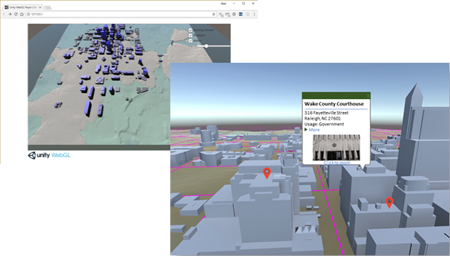
Micasa™ - is a system that uses full-motion video, from multiple UAVs, and generates in real-time, fully textured scalable 3D models (e.g., buildings, terrain, etc.) from point cloud data, with sufficient accuracy to allow precise measurement, supporting U.S. DoD’s manned/unmanned mission command via lightweight 3D use. Feature attribution and target recognition and tracking are also included with the 3D Micasa offering.

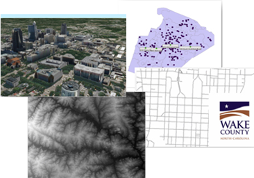
AMCON Geo™ - is an innovative Artificial Intelligence framework for automatically combining, via dynamic conflation, multiple intel sources together in a geospatial foundation to increase operational throughput. AMCON Geo puts all of the data together in an easy to visualize, and easy to distribute, data package suitable for Web-centric use. AMCON Geo translates the data layers into general “foundation data” containers having associated attributes, each of which is suitable for a specific type of data (e.g., raster, vector, point, geographically linked, etc.).
Typical input layers: 3D structures, point data, terrain, road networks, and more.
AMCON Geo's consolidated viewer, providing interactive 3D conflation content output
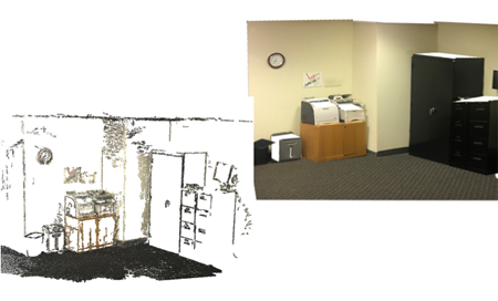
Hamm™ - automatically generates accurate, timely, as-built 3D models of building interiors from video collected by handheld or body-mounted devices (e.g., smartphones, body cams, etc.). Once the 3D model is complete, an as-built Machine Learning floor plan is also computed directly from the 3D geometry. Transmission and lightweight use via the “GeoPackage” data exchange standard is part of the Hamm solution, and that helps ensure future alignment with Web use and Cloud processing and exchange.
Hamm offers the ability to generate 3D content of interiors, in real-time, using hand-held phones, tablets, and other similar consumer devices. Shown here: (left) point measures and (right) 3D model output.
Micasa user interface and real-time 3D model output from UAVs.