Copyright 2020: International Association of Virtual Organizations, Inc. All rights reserved.

Geosciences and 3D Modeling
Our work in geosciences, imagery processing, and 3D modeling responds to the various growing interests in geodata, information extraction, and data visualization. Client examples include the US Government (e.g., military, transportation, interior, commerce, justice, etc.), local and state governments, developers, and many commercial entities.
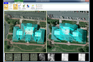
Our imagery programs showcase capabilities ranging from applications development to an array of production support specializations. Most of our work is utilizes by our geo-related software products GeoGenesis®, IApioneer™, OmniDEM®, and FeatureXTract™.


Geosciences: Commercial Software
Our current commercial software products are aligned with our long standing expertise in geosciences, mapping and photogrammetry, analysis, digital elevation modeling, and precise 3D feature modeling.
Geosciences: Systems Development
Our systems development is based primarily on our GeoSPHERIC™ common code foundation, web-based engines, and user-specified frameworks.
Geosciences: Technical Services
Our imagery services respond to increasing interests in "geodata" and include the US Government (e.g., military, transportation, interior, etc.), local and state governments, developers, and many commercial entities.